Drones could help researchers count salmon nests
Searching for the places where salmon lay eggs, known as redds, is getting a boost from some eyes in the sky. A new study from Washington State University used drones to survey salmon redds along parts of the Wenatchee River.
Salmon migrate sometimes hundreds of miles from the ocean to the streams where they were born to lay eggs. Traditionally, surveying salmon redds can mean walking for miles or floating in a boat, peering through the water for mounds of large gravel where female salmon buried their eggs.
Surveys of redds can be limited by the time and distance people have to travel, said Daniel Auerbach, a doctoral candidate at WSU and lead author of the study.
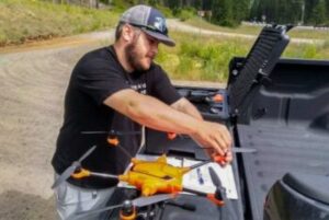
Daniel Auerbach sets up a drone. CREDIT: McClain Johnson
“We’re limited on the ground by how far we can walk or how long we can concentrate. There’s so many different factors that go into the studies that we do. And it’s also how well our eyes can see,” Auerbach said.
With drones, time and distance aren’t as much of a factor. The drones he used for his study could fly for around 45 minutes. Due to Federal Aviation Administration rules, pilots had to keep the drones within their line of sight, which meant the drones could fly roughly one-third of a mile, Auerbach said.
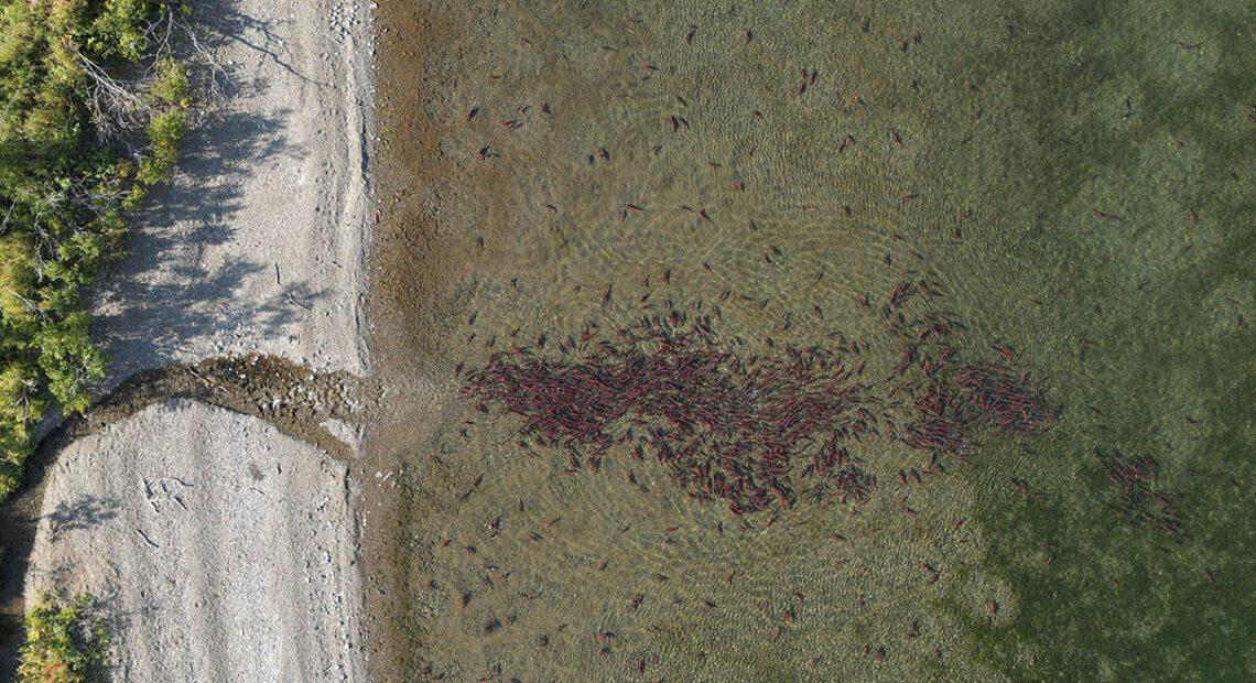
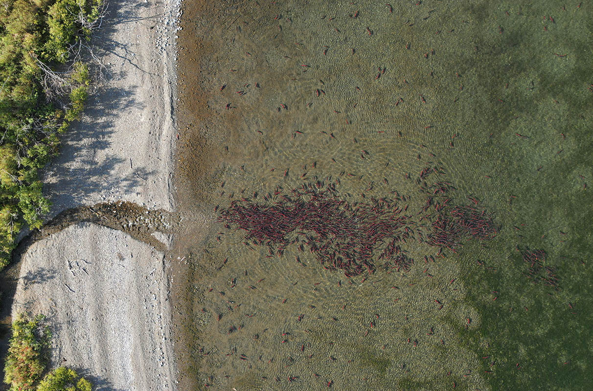
In this study, researchers surveyed three parts of the Wenatchee River known for densely packed salmon redds. Each week during the 2020 chinook spawning season, researchers flew the drone 150 feet in the air above the river. Four different people, called observers, studied the photographs to count the redds.
The high-resolution photographs allowed researchers to refer back to images of the Wenatchee River, he said.
The photographs also could allow researchers to study images and habitat changes overtime, said Alex Fremier, study co-author and an associate professor in the WSU School of the Environment.
In addition, multiple images could help researchers monitor efforts to help salmon, from habitat restoration to dam removal, which will give researchers more data, he said.
“Because we can get so much information from these images, we could be more cost effective and help determine if a restoration project helped build salmon habitat,” Fremier said.
While counting the redds, reviewers estimated many more redds in the drone photographs than surveyors did on the ground, which Auerbach said is one reason this tool should supplement traditional surveys.
“I think we were all hoping that it would be 1-to-1, that we would get the exact same number that we got on the ground or at least relatively close to it,” Auerbach said.
Observers also came up with about double the number of redds, with counts sometimes varying among observers by 80 redds.
The counts most often appeared off because one female had dug a redd on top of another redd, known as superimposition, he said.
“So it’s hard to distinguish whether it’s one redd or two redds,” Auerbach said.
Miscounts also happened when features of the river obscured the photographs.
“Whether it’s because of the river flow or a log in the river or something like that, it’s causing the river to appear like there’s a redd there,” he said.
The best ways to spot the redds were from changes in the color of the substrate and the redd, which happens when female salmon dig around and clean off gravel covering the redds.
“Those rocks appear much lighter compared to the surrounding substrate,” Auerbach said.
Sometimes, observers also could see the topography of the redd where the salmon have dug, he said. Another clue could be female salmon guarding the redd, although that wasn’t as much of an indicator because the salmon might not always stay next to the redd it dug, he said.
“On a perfect day, you can see things just as well through the water as you can on land,” Auerbach said, of the drone flights.
However, peering into water from a drone is sometimes tough, Auerbach said, because clouds and shade cause challenges, as does the river.
“Water goes over rocks, and you get ripples that obscure your view. And depending on how deep the water is, you lose color totally, and your object becomes distorted,” he said.
All that can be mitigated, he said, especially as drone technology continually improves.
The Washington Department of Fish and Wildlife is considering the potential use of drones to supplement salmon and steelhead monitoring efforts, said Ben Anderson, a spokesperson for the department.
“We’ll want to further evaluate and potentially conduct follow-up studies to determine if we will use drone surveys for counting redds in the future. We do already use drones for a variety of purposes, including wildlife monitoring and determining if habitat restoration projects are functioning as designed,” Anderson said.
In wildlife management, typical surveys by helicopter or on foot can often be stressful for wildlife, Auerbach said. As drone technology has taken off, many surveyors have started to supplement their field work with drone flights.
“Drones are less invasive, and they cover a larger area than we can probably cover on the ground or using traditional methods at a resolution that is up to par with what we get on the ground in many instances,” Auerbach said.
The researchers are now analyzing similar data from 2021, for a second study in conjunction with the Washington Department of Fish and Wildlife.
While drones won’t replace biologists in the field, Auerbach said he hopes to expand the use of drones in fisheries sciences, including expanding this type of study to survey an entire river.
“How far can we take drones, and how far can they be brought in the studies that are being done on the ground,” Auebach asked, of using a newer piece of technology.